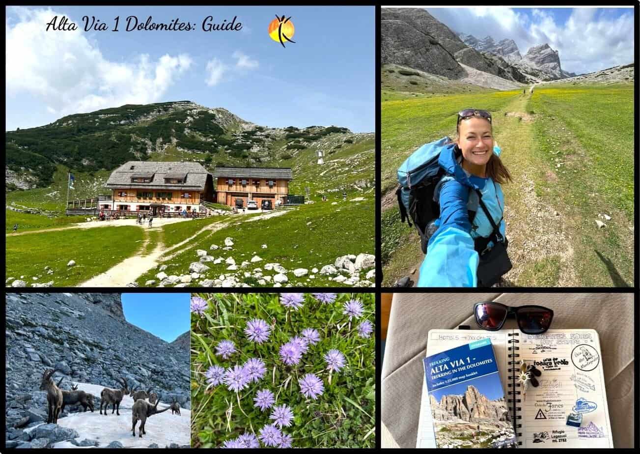

Alta Via 1 is one of the most popular hut-to-hut hiking trails in Europe. It’s located in the Italian Alps, called the Dolomites. I got a chance to hike the Alta Via 1, and let me tell you – it was an experience of a lifetime.
I loved every single second of it. The views are constantly changing, sleeping in the huts is such an authentic experience, and you’ll really get to the entire mountain range. I fell in love with the Dolomites so much so that I moved here 5 months later.
In this guide, I’ll give you all the information you need to hike Alta Via 1 and help you plan your perfect hiking trip, based on my experience.
Ready? Let’s gooo!
What Is Alta Via?
Alta Via 1 is a popular hut-to-hut hiking trail (or a multiday trail) in the Dolomites, Italian Alps. It takes about 8- 11 days to complete the entire route. You’ll be walking from the northern part of the Dolomites (Val Pusteria) to the southern part (Veneto).
You’ll spend the night in local rifugios (mountain huts) as you cross the mountains. Every rifugio is different, and all of them offer breakfast and dinner included.
Pack everything you need to hike the entire trail into a backpack, and you carry it as you walk through.
You can hike it on your own, following signs (and I recommend getting a guidebook to see the sections to cover each day), or you can join an organized tour with a company.
Travel Itinerary Planning &
1-On-1 Call With Me
| ✈ Did you know? I design customized travel itineraries. |
|---|
| ➡ Whether you’re traveling somewhere for the first time and don’t know where to start and how to plan your trip… ➡ Or you don’t want to spend a thousand hours planning your perfect trip… 👉 LET ME HELP YOU – I’ll design a travel itinerary based on your needs and interests (fill out the form below 👇). |
Or book a call with me to chat in real time, ask me any questions, and get personalised travel advice for your trip.
👉 Click here to book a call.
Alta Via 1 Elevation
It has a significant elevation gain of approximately. 6600 – 7400 m. (21000 – 24000 ft.) and descents also over 7000 m./22000 ft. The trail constantly changes up and down, some sections are pretty demanding with steep ascents, and some days are less difficult with more flat pathways.
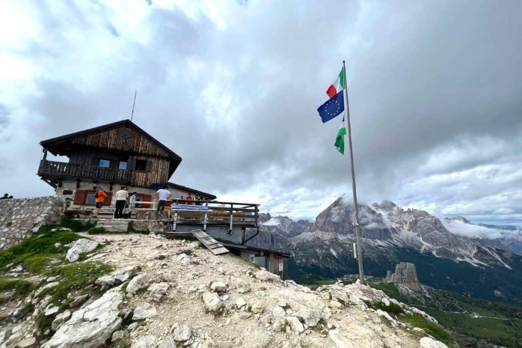
The highest point of the entire trek is Rifugio Lagazuoi (2752 m/9029 ft.).
You don’t need special equipment to hike it (there are no Via Ferrata sections with ropes/chains). Just fit legs and a positive mind, you’re good to go.
Alta Via 1: Itinerary & Entire Trail With Highlights
Here is the entire itinerary for you to hike Alta Via 1. Follow it and make rifugio reservations accordingly.
| I plan customized travel itineraries – if you’d like me to help you plan your Alta Via 1 more in detail, with maps, and descriptions of each stage, contact me at [email protected]. I’ll be excited to create a self-guided itinerary for you to hike it. Or book this 1-on-1 travel chat with me (consultation), so I can answer all your questions and help you plan in real time. |
Alta Via 1: Overview With Stats
| COUNTRY: Italy (Dolomites) NUMBER OF DAYS: 8 – 11 Days DISTANCE: 120km /75 miles (all on foot) ELEVATION GAIN: 7400 m/24000 ft. HIGHEST POINT: 2752 m/9029 ft. SEASON: mid June – late September DIFFICULTY: Medium STARTING POINT: Lago di Braies (Val Pusteria) ENDING POINT: La Pissa (Belluno town in Veneto) |

Alta Via 1: Map With Rifugios
Start Of Alta Via 1
The trek starts in Lago di Braies (Lake Braies) in the Val Pusteria region of the Dolomites.
The best way to reach it is to fly to Venice.
From Venice, take a bus directly to Cortina d’Ampezzo (takes about 2.5 hours). You can stay overnight in Cortina to prepare and enjoy the town (that’s what I did). Or do some of the best hikes in the Dolomites in the area for a couple of days, to prepare for your big adventure.
➡ Check out my post about where to stay in Cortina for best hotels I recommend.
From Cortina, you’ll take a local Sudtirol Mobilità bus to Dobiacco. And in Dobbiaco, you’ll change to another bus that will take you directly to Lake Braies.
Alternatively, you can fly to Munich and take trains to Bruneck. From Bruneck, take a bus to Dobbiaco, and then the same bus to Lago di Braies.
➡ Check out the bus timetable to get to Lago di Braies here.
1. DAY: Lago Di Braies – Rifugio Biella
| DISTANCE: 6 km/3.7 miles TOTAL ASCENT: 870 m/2854 miles TOTAL DESCENT: 60 m/196 miles TIME: 3 hours & 20 minutes |
The first section is a more challenging side with some steep ascending, as you start at Lago di Braies. It will take you about 3.5 hours to hike to Rifugio Biella, which is the destination for tonight.
It was one of my favorite trails of the entire trek, as the scenery changed all the time – and I even saw herds of chamonix jumping around me. It was epic.
You can easily start around 2:00 PM at the lake, and get to Rifugio Biella at around 5:30 PM, right for dinner.


2. DAY: Rifugio Biella – Rifugio Pederu – Rifugio Fanes
| DISTANCE: 13 km/8 miles TOTAL ASCENT: 710 m/2329 miles TOTAL DESCENT: 980 m/3215 miles TIME: 4 hours & 30 minutes |
Good morning to Rifugio Biella. I hope you enjoyed the night at your first Italian mountain hut. Take some time in the morning to enjoy breakfast, before you set off. You’ve now entered the stunning Fanes-Senes-Braies National Park of the Dolomites.
The first half of your day is going to be very pleasant, following a pasture trail until you reach Rifugio Pederu. Then a steep section starts again as you’re hiking to Rifugio Fanes, which will be your destination today. Again, one of my favorite days of Alta Via 1, and you’re in the middle of the meadows full of flowers. It’s so peaceful, it almost feels like heaven.


3. DAY: Rifugio Fanes – Forcella del Lago – Rifugio Lagazuoi
| DISTANCE: 12.2 km/7.6 miles TOTAL ASCENT: 1150 m/3772 miles TOTAL DESCENT: 450 m/1476 miles TIME: 5 hours & 30 minutes |
Hello to Fanes. Prepare for the most difficult day of the entire Alta Via 1 today. You’ll be hiking to the highest point of your entire trek – Rifugio Lagazuoi – and it will be 100% worth it.
The first part of the day is similar to yesterday, as you walk through the green pastures in the middle of nowhere – simply breathtaking. After, you’ll start ascending via Forcella del Lago and Forcella del Lagazuoi until you reach the Lagazuoi mountain hut (the difficult part).
The entire trail takes about 5.5 – 6 hours, and well, the scenery is absolutely amazing.
NOTE: Rifugio Lagazuoi is almost always booked out, even a year in advance. So, if you have difficulties booking a bed here, pivot and stay in nearby rifugios such as Rifugio Scotoni (on the way), or Rifugio Col Gallina (a bit further away – close to Passo Falzarego).


4. DAY: Rifugio Lagazuoi – Passo Falzarego – 5 Torri – Rifugio Nuvolau
| DISTANCE: 12.8 km/7.95 miles TOTAL ASCENT: 1100 m/3608 miles TOTAL DESCENT: 1275 m/4183 miles TIME: 5 hours & 30 minutes |
This might be the day when you sleep the least, as I highly recommend waking up early to see the sunrise from Rifugio Lagazuoi. It’s unlike any other I’ve seen in my life (and I’ve seen so many, it’s always on my list to spot an epic sunrise).
You’re now entering 5 Torri and one of the most historically important areas of the trek.
Lagazuoi and 5 Torri were part of serious battles during WWI, as the Austrian and Italian troops fought for the territory here. As you descend from Lagazuoi, you’ll be walking through trenches and impressive tunnels, where the Austrian troops were hiding.
5 Torri has a loop you can follow (from Rifugio Scoiattoli) to learn more about these battles; it’s pretty interesting.
From there, start ascending to Rifugio Nuvolau at the top of the mountain, which will be your destination. And prepare for an epic sunset (perhaps the most beautiful on the entire trail).


5. DAY: Rifugio Nuvolau – Passo Giau – Rifugio Citta Di Fiume
| DISTANCE: 12.8 km/7.95 miles TOTAL ASCENT: 500 m/1640 miles TOTAL DESCENT: 1200 m/3937 miles TIME: 5 hours |
Good morning to Rifugio Nuvolau. Today, you’ll be descending to one of the most famous mountain passes in the Dolomites – Passo Giau. From there, start ascending to Forcella Giau with occasional chains on the way.
You’ll then be descending more or less the entire way for the rest of the day, until you reach Rifugio Citta di Fiume.

6. DAY: Rifugio Citta Di Fiume – Forcella Val d’Arcia – Rifugio Coldai
| DISTANCE: 9.3 km/5.77 miles TOTAL ASCENT: 560 m/1837 miles TOTAL DESCENT: 340 m/1115 miles TIME: 3 hours & 30 minutes |
Today is only about 3.5 hours of hiking, but the first section is again quite steep, as you hike from your rifugio towards Forcella Val d’Arcia.
From there, you can relax your legs a bit as you’ll be descending for the rest of the day to Rifugio Coldai, which is your place to stay for the night. The last section is again a bit steeper as you hike up to the rifugio.


7. DAY: Rifugio Coldai – Rifugio Tissi – Rifugio Vazzoler
| DISTANCE: 9.8 km/6 miles TOTAL ASCENT: 450 m/1476 miles TOTAL DESCENT: 850 m/2788 miles TIME: 3 hours & 30 minutes |
Prepare for some more breathtaking scenery today, as you’ve made it to another region of the Dolomites – Civetta.
Enjoy the stunning views of Lago Coldai (lake) close to your rifugio. Then hike to Rifugio Tissi, where you can enjoy some Italian lunch.
After, you can relax your legs again and breathe out for the rest of the trail, as it’s only descending to Rifugio Vazzoler, where you’ll sleep tonight.


8. DAY: Rifugio Vazzoler – Rifugio Carestiato
| DISTANCE: 8.7 km/5.4 miles TOTAL ASCENT: 620 m/2034 miles TOTAL DESCENT: 500 m/1640 miles TIME: 3 hours & 20 minutes |
Today is a much lower altitude day, as you’ll be passing through a lot of greenery, on the edge of the Rocky Mountains (not walking through them). So, the scenery might not be as spectacular as on the other days, but it’s still pretty amazing.
You’ll cover about 8.7 km (5.4 miles) today, with some steeper sections for the second half of the day. Your destination is Rifugio Carestiato.
NOTE: You might choose to end your Alta Via 1 here and make a detour, not following the trail to Rifugio Carestiato. Instead, you can hike down to Listolade town and take a bus from there anywhere you want to go.


9. DAY: Rifugio Carestiano – Forcella Dagarei – Rifugio Pramperet
| DISTANCE: 13.2 km/8.2 miles TOTAL ASCENT: 620 m/2034 miles TOTAL DESCENT: 600 m/1968 miles TIME: 4 hours & 20 minutes |
Expect more pastures, meadows full of flowers, and quiet areas as you enter the Bellunese National Park today. You’ll hike for about 13 km, and the trail is one of the easiest on the Alta Via.
The hut you’ll stay in for the night is called Rifugio Pramperet.
10. DAY: Rifugio Pramperet – Forcella de Zita Sud – Rifugio Pian de Fontana
| DISTANCE: 6.2 km/3.85 miles TOTAL ASCENT: 540 m/1771 miles TOTAL DESCENT: 760 m/2493 miles TIME: 3 hours |
You’re now in the heart of Bellunesi National Park, which offers some of the prettiest scenery of the entire Alta Via 1. So, take it easy today and soak up the entire vibe. You might spot a lot of wildlife and enjoy unique flowers growing along the way.
There is another big climb in front of you, as you hike from the rifugio to the top of Forcella de Zita Sud with rocky terrain. But, once you’ve made it, you’ll only descend to your next rifugio, which is Rifugio Pian de Fontana for tonight.
11. DAY: Rifugio Pian de Fontana – Rifugio Bianchet – La Pissa
| DISTANCE: 11 km/6.8 miles TOTAL ASCENT: 200 m/656 miles TOTAL DESCENT: 1400 m/4593 miles TIME: 4 hours & 15 minutes |
Last but not least, you’ll be walking through the famous Bishop’s Valley (Val Vescova), enjoying a pretty easy descent, as you’re finishing the entire trek today.
Stop at Rifugio Bianchet for lunch and take it all in for the last time, before you descend to La Pissa.
Congratulations, you’ve hiked the entire Alta Via 1 in the Dolomites!
End Of The Alta Via 1
Once you finish in La Pissa, you can take a bus to the nearby town called Belluno. I recommend spending the night here and reflecting on your trek.
From Belluno, you can take a bus back to Venice, or return to Cortina d’Ampezzo, if you want to keep enjoying more of the Dolomites in summer.
Practical Tips To Hike Alta Via 1 In The Dolomites
Here are all my tips to help you plan your hiking trip. Let me know if you have any questions.
How Long Does It Take To Hike Alta Via 1?
It takes 8 to 11 days to hike the entire Alta Via 1. The official trail takes 11 days, and it’s divided into 11 stages.
However, you can easily make it in 8 days, merging some of the sections, if you’re an experienced hiker and would like to hike a bit more than the guidebooks say on some days.
Best Time To Hike Alta Via 1
End of June/beginning of July or mid-September are the best times to hike the Alta Via 1.
End of June is the most beautiful time as the meadows are full of flowers, everything is lush green, lakes are full of water melted from the glaciers – it’s my favorite time to hike the Dolomites. And it’s also less crowded than during the peak summer season.
Another great time is beginning or mid-September, which is also less crowded. But the nature is not as nice as in June.
The majority of the rifugios (mountain huts) open early or mid-June and close for the winter season at the end of September. So, it’s not possible to hike the Alta Via 1 any other time of year other than summer.
Where To Stay While Hiking Alta Via 1
You’ll stay at local mountain huts, which in Italian are called ‘rifugios‘. It’s like a mountain refuge in the middle of the mountains, and there are plenty of them on the way.
The guidebooks suggest particular huts, which sell out pretty fast. However, there are several huts on the way and around these main suggested huts, so you can always pivot and find a refuge to sleep at.
Here are the mountain huts I recommend booking for your Alta Via 1 experience. I’ve ranked them as the trail goes, so once you’re planning your trek, you can just take this list and make reservations one by one:
🏠 Rifugio Biella (Day 1.)
🏠 Rifugio Fanes (Day 2.)
🏠 Rifugio Lagazuoi (Day 3.)
🏠 Rifugio Nuvolau (Day 4.)
🏠 Rifugio Citta di Fiume (Day 5.)
🏠 Rifugio Coldai (Day 6.)
🏠 Rifugio Vazzoler (Day 7.)
🏠 Rifugio Carestiato (Day 8.)
🏠 Rifugio Pramperet (Day 9.)
🏠 Rifugio Pian de Fontana (Day 10.)


Alta Via Dolomites Hut Booking
Most huts have a website with an online booking platform, where you can book the room. You can also write them an email or call (if they don’t have a website). I communicated with many of them via email, and they’re pretty quick to reply.
You’ll usually have to pay a 30% – 50% deposit at the time of booking. And the rest can be paid cash or by card as you arrive (after your stay).
NOTE: Some rifugios only accept cash, although most of them take cards. But I recommend checking in with each of them before your trip to see if they only take cash, so you have enough for the entire trip.
An overnight stay at an Italian rifugio costs approximately. $80 – $100 (around 65 – 80 EUR) per person, which includes a bed (sometimes in a multibed room, sometimes in a 4-bed room), 3-course dinner, and breakfast. It’s also possible to book a 2-bedroom in most cases, which costs more.
Most rifugios have a shower, but the higher in the mountains you are, the more basic the shower is. I’ve experienced everything from tiny showers without running water (so I was pouring some water on me from a bottle), to showers with a token, so you have 5 minutes to take a shower, no shower at all, but also rifugios that have a full shower with running hot water.
So, expect anything and everything :D.

Packing List For Alta Via 1 In The Dolomites
I know you guys have always so many questions about packing. So, here is everything I packed and what you’ll need to hike the Alta Via:
👉 4 T-Shirts, 1 sweater, 1 waterproof and windproof jacket, 1 long-sleeve shirt, 2 pairs of shorts, 1 pair of hiking panths, 1 pair of leggings, 1 set of clothes for the rifugios, bottle of water, sunscreen, sunglasses, toilettries, 1 pair of hiking boots, 1 pair of sneakers, 1 flipflops (for showers – optional), a guide book for Alta Via 1, a journal for the rifugio stamps and write about your experience, underwear, a hut/cap.
Pack it all into a 40 – 50L backpack, and you’re good to go :).
Also, get a guidebook, so you can read about each section, and it will also help you plan before your trip! I loved hiking around with my little book; it’s such a great companion.
You can also get some snacks like protein and muesli bars. But there is always a possibility to buy food as you hike in the local rifugios, which are spread out on the trail.

How Much Does It Cost To Hike Alta Via 1? Budget You’ll Need
Plan to spend about $180 per day per person (about 150 EUR), including all meals, overnight stay in rifugios, and extra drinks + miscellaneous.
So, let’s say about $1900 (or about 1600 EUR) for the entire Alta Via 1 trek that would take you 10 days, including transportation to the start and after you finish it.
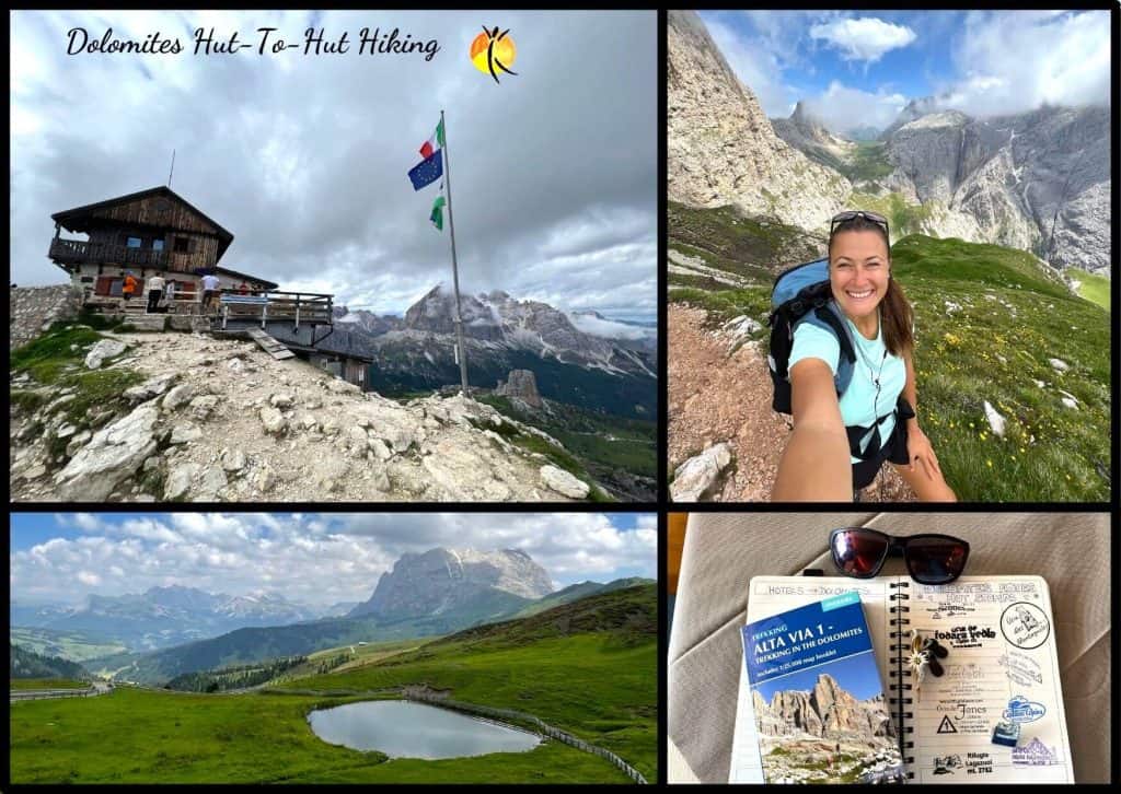
BONUS: Dolomites Hut-To-Hut Hiking: Amazing Trails & Tips
I’ve also written a separate article about hut-to-hut hiking in the Dolomites, in which I describe more routes and multiday hikes, including those I’ve created on my own.
So, check it out for more inspiration, if you want to hike in the more hidden gems of the Dolomites:
FAQs
I’ve also answered some of the frequently asked questions for you, so check my answers below:
Where Does The Alta Via 1 Start?
It starts at Lago di Braies (Lake Braies) in the Val Pusteria region of the Dolomites. The best way to get there is by taking a bus from Cortina (via Dobbiaco) or from Bruneck (also via Dobbiaco).
Where Does The Alta Via 1 End?
It ends at the La Pissa stop in the town of Belluno, in the Veneto region of the Dolomites. From there, you can easily return to Cortina d’Ampezzo and to Venice.
Is It Difficult To Hike The Alta Via 1?
It’s a medium difficulty hike on the Alta Via 1. If you’ve never hiked before or don’t exercise/walk regularly, some sections are a bit more challenging and might be difficult for you. But overall, it’s pretty easy with a medium fitness level.
I think anyone can do it, even the harder sections, if you take your time.
What Is The Difference Between Alta Via 1 And 2 In The Dolomites?
Alta Via 1 is easier than Alta Via 2, and you also don’t need any equipment. Alta Via 2 is more challenging with steeper sections and Via Ferratas, and you’ll need special equipment for it, like ropes to climb.
Alta Via 1 can be done without a guide on your own, while some sections of Alta Via 2 require a guide.
Is Alta Via 1 Beginner-Friendly?
Yes, Alta Via 1 is beginner-friendly. It’s the best trek if you’re only starting with hiking such treks.
Can You Camp On The Alta Via 1?
No, it’s prohibited to camp in the Dolomites.
WRAP-UP: Alta Via 1 Dolomites
This is my experience and all you need to know to hike the Alta Via 1 in the Dolomites. It’s such an amazing experience, and if you’re still hesitant, don’t be. You’ll be glad you did it. So, book that flight and the rifugios, pack, and off you go.
If you have any questions, write me an email at [email protected]. I’ll be happy to create a customized travel itinerary for your hiking trip in the Dolomites and help you book the rifugios. Or book this 1-on-1 travel chat (consultation) with me, so I can help you plan in real time.
Happy Trekking in the Dolomites!
More Tips For Italy Travel
Looking to visit more places in Italy? Check out my related articles:
Best Of Northern Italy Itinerary: 10 Days With Tips
Where To Stay In The Dolomites: Best Areas & Hotels
Where To Stay In Cortina d’Ampezzo: Best Hotels For Winter & Summer
Best Hikes In The Dolomites That Will Take Your Breath Away
Dolomites Itinerary: 5 Unforgettable Days In The Italian Alps
Dolomites In Summer: Best Things To Do & Itineraries
Epic 3-Day Hike In The Dolomites: Self-Guided Itinerary
Unique 5-Day Hike In The Dolomites: Self-Guided Itinerary
Dolomites In Winter: Best Things To Do & Pleaces To See
Alpe Di Siusi (Dolomites): Guide For Your Visit
Val Gardena [Dolomites]: Full Guide & Best Things To Do
Dolomites Hut-To-Hut Hiking: Amazing Trails & Tips
Is Seceda Worth It? All You Need To Know For Your Visit
Skiing In The Dolomites: Full Guide & My Experience
Italy In Summer: What To Do & Where To Go By An Expert
Milan To Amalfi Coast: Ultimate Guide
9 Best Hotels In Amalfi Town Italy
How To Make A Day Trip From Rome To Amalfi Coast: Full Itinerary

About the author: Nicoletta is a travel enthusiast and passionate language learner. While traveling, she loves to connect with locals using her language skills to learn about new cultures. Look for her skiing, hiking in the mountains, or exploring new destinations as she designs travel itineraries for her clients.
ITALY: Interested in more articles for Italy?
Check out my Italy Travel Page:

![Read more about the article Is Portugal In Spain? Ultimate Guide [2026]](https://voicesoftravel.com/wp-content/uploads/2023/11/is-portugal-in-spain-300x213.jpg)
![Read more about the article Best Of Southern Spain Itinerary: 10 Days In Andalusia [2026]](https://voicesoftravel.com/wp-content/uploads/2021/11/southern-Spain-itinerary-10-days-300x213.jpg)
![Read more about the article How Far Is Barcelona From Paris? Complete Guide [2026]](https://voicesoftravel.com/wp-content/uploads/2023/11/how-far-is-barcelona-from-paris1-1-300x213.jpg)